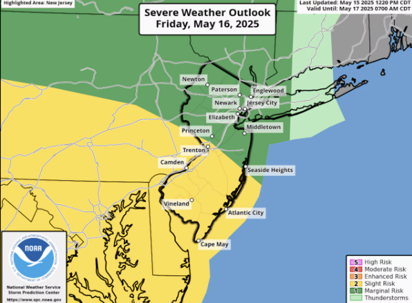
Forecasters warn that thunderstorms could hit New Jersey on Friday, bringing strong wind gusts and large hail. The northern half of the state faces a marginal risk of severe storms, while the southern half is under a slight risk, according to the Storm Prediction Center. On the five-tier risk scale, marginal is the lowest level and slight is the second lowest.
There’s also a small possibility of an isolated tornado in far southern areas of New Jersey, particularly in Cape May, Cumberland, and Salem counties, with a 2% to 4% chance of development. The same risk extends across parts of Delaware.


Storms Fueled by Warm Front
Friday’s storms are expected to form as a warm front pushes across New Jersey during the morning and early afternoon. However, forecasters say there’s still uncertainty about how intense the storms will be when they hit.
As of Thursday afternoon, the National Weather Service predicted a 60% chance of showers and storms Thursday evening, mainly before 8 p.m., along with patchy overnight fog.
Friday’s forecast includes a 50% chance of storms in the morning and afternoon, tapering to 40% by the evening. Temperatures will climb into the upper 70s and possibly low 80s across some areas.
More Storms on Saturday
The unsettled pattern continues into Saturday as a cold front moves in, likely sparking more thunderstorms. Some could again become severe, producing damaging winds and hail.
This comes after three straight days of damp, overcast weather, with most of the Garden State receiving between 1 and 3 inches of rain. Some towns saw up to 4 inches, surpassing their average rainfall for all of May.
Break in the Rain Expected Sunday
Dry weather is finally in sight for Sunday, with clearing skies and temperatures in the low to mid-70s. Winds may become gusty in the afternoon.
Looking ahead, the start of next week should remain dry, but meteorologists are watching for a potential coastal storm midweek. If it develops, it could bring another round of soaking rain to New Jersey.