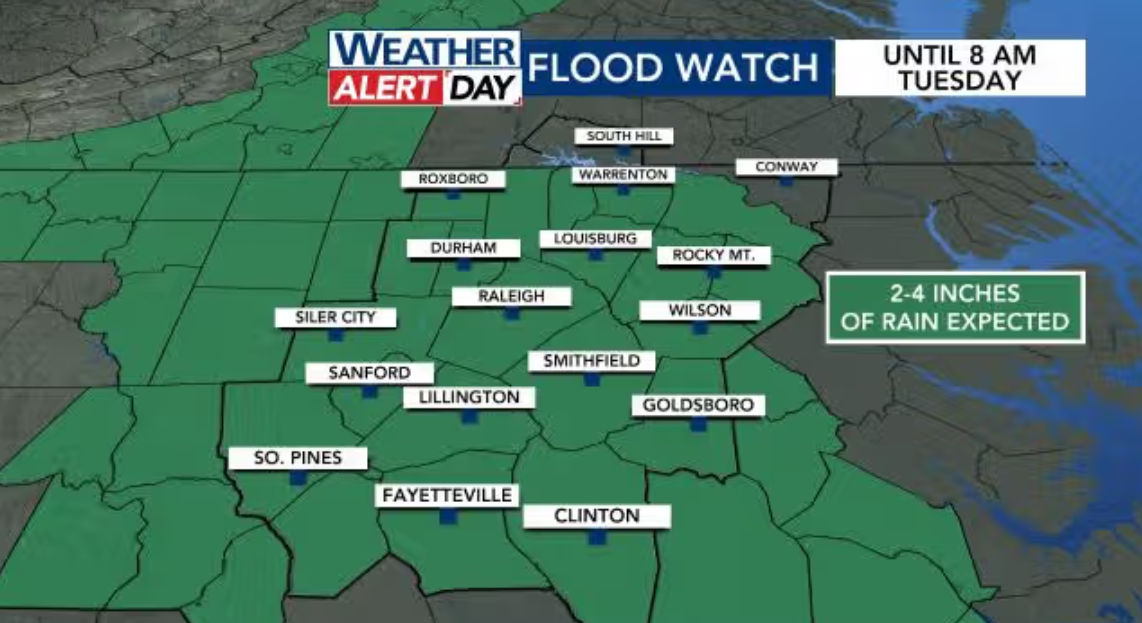
Monday and Tuesday are WRAL Weather Alert Days due to a flood watch issued for most of our area.
Expect dense fog and scattered showers during the morning commute on Monday, with heavier rain forecast later in the day.
Forecast:
-
Monday: WRAL Weather Alert Day. Expect rounds of heavy rain, with localized flooding possible. Highs in the lower 70s.
-
Tuesday: WRAL Weather Alert Day continues through the morning commute due to the potential for heavy rain. Scattered afternoon storms. Highs in the upper 70s.
-
Wednesday: Mostly cloudy skies with scattered showers and storms. Highs in the upper 70s.
Weather Overview for Monday and Tuesday:
An area of low pressure from the Gulf will bring heavy rain and storms over the next three days. Rain will start as scattered showers on Monday morning, becoming more widespread by afternoon.
A flood watch is in effect for most of the area until 8 a.m. Tuesday, prompting the WRAL Weather Alert Day during this period.
Flood Watch in Effect Until 8 a.m. Tuesday:
Rain totals of 2 to 5 inches are expected, which could cause creeks, streams, and rivers to swell due to the heavier rain.
Forecast Details for Monday through Tuesday Morning:
Monday will see the most rainfall, according to WRAL meteorologist Chris Michaels. While the forecast models show the projected rain totals, any storms could produce localized higher amounts.
By Tuesday afternoon, the rain will become more scattered, and we may also need to monitor the possibility of severe thunderstorms later in the day.
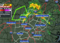
Tuesday, May 13 Hour-by-Hour Rain Chances:
The low-pressure system will continue to bring widespread rain until late Wednesday morning, before clearing out that evening.
Chris Michaels explains, “This system will bring one last wave of widespread showers and storms starting late Wednesday morning, clearing later that night. Any water-logged ground may flood easily.”
Daily and Nightly Rain/Storm Chances Through Wednesday, May 14:
Some of this rainfall will benefit the eastern half of the state, where drought and wildfires have been persistent concerns in recent weeks.
Temperature and Weather Outlook for Later in the Week:
The pattern will begin to break, and temperatures will rise later in the week. After scattered showers and storms on Wednesday, we’ll see drier conditions Thursday through Saturday.
Chris Michaels notes, “Thursday will be mainly dry as high pressure takes over, and the same goes for Friday. A weak front could trigger a few stronger evening storms Friday.”
Heat Returns Later in the Week:
By Friday, highs will reach the lower 90s in the Triangle and the Sandhills.
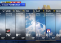
7-Day Forecast for Central NC:
-
Monday: Mostly cloudy with returning showers. Highs in the low 70s.
-
Tuesday: Heavy rain likely. Highs in the upper 70s to near 80 degrees.
-
Wednesday: Mostly cloudy with scattered showers and storms. Highs in the upper 70s.
-
Thursday: Partly cloudy with a stray shower. Highs in the mid to upper 80s.
-
Friday: Partly cloudy, hot, and humid with a few late-day and evening storms. Highs in the upper 80s to lower 90s.
-
Saturday: Warm again with a few possible storms. Highs in the middle 80s.
-
Sunday: Mostly sunny and warm with highs in the mid to upper 80s.