
A stalled weather boundary near the coast is causing widespread showers and thunderstorms in southeast Texas from this morning until early afternoon, with isolated severe storms possible. The most severe dangers, including hail, powerful wind gusts, and locally heavy rainfall, will mostly affect regions south of I-10 and along the coast.
According to the National Weather Service, storms may intensify and reach category 2 severity on a scale of 0 to 5, with coastal regions concerned about isolated flooding. Strong gusts and huge hail are predicted, and marine conditions will deteriorate with elevated winds and choppy waves near thunderstorms.
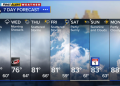
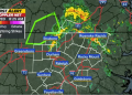
Houston, Galveston, and Freeport are among the most heavily impacted places, with rains potentially disrupting commutes and isolated flooding threatening roadways and low-lying areas. Drivers should use caution, especially near the coast, and be prepared for rapid changes in weather conditions.
Warnings are in effect until early afternoon, and people are asked to stay prepared. Keep up with weather notifications and save unnecessary trips.