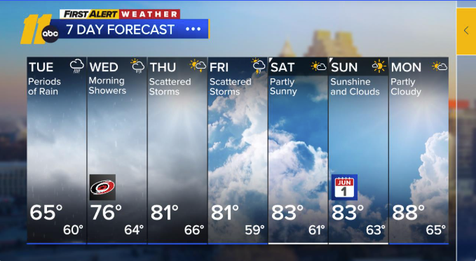
A gloomy and wet Tuesday is unfolding as widespread rain moves in from the west, linked to a disturbance and low-pressure system currently over eastern Mississippi. Rain is expected to pick up during the morning commute and continue through the afternoon and evening, with the potential for a few thunderstorms.
Cooler Than Normal Today
Morning temperatures are in the 50s and 60s, and highs will only reach the mid-60s—about 15 to 20 degrees cooler than average for late May. Rain will continue into the night, with lows near 60. Some areas could see rainfall totals over an inch by Wednesday morning.


Midweek Changes
Wednesday starts with scattered rain and a few storms, but conditions will dry out by late morning. Expect afternoon highs in the mid-70s to low 80s, with overnight lows in the mid-60s. A stray thunderstorm may pop up Wednesday night.
More Showers Before a Sunny Weekend
Rain and thunderstorm chances return Thursday afternoon and may linger through Friday night and possibly early Saturday. Highs Thursday and Friday will stay in the low 80s.
By Saturday, drier air will begin to move in. The weekend looks warmer and more pleasant, with highs in the low to mid-80s. High pressure will take over early next week, pushing Monday’s highs into the upper 80s to near 90.